CryoSat 2 sent its first data back to earth on Tuesday, five days after the University College London-led mission got underway when the satellite lifted off from the Baikonur Cosmodrome in Kazakhstan.
Data began transmitting just hours after European Space Agency ground controllers switched on the satellite’s radar instrument for the first time. CryoSat-2 was launched on 8 April and ESA says it has been performing exceptionally well during its critical first few days in orbit.
The CryoSat mission to map the Earth’s ice cover is the inspiration of Duncan Wingham, a professor at the Centre for Polar Observation and Modelling at UCL. This is Europe's first mission dedicated to studying variations in the planet’s ice cover. An earlier satellite, CryoSat 1, crashed just after take off in 2005.
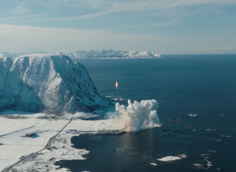
CryoSat 2 was launched at 15:57 CEST, 8 April, on a Dnepr rocket provided by the International Space Company Kosmotras, from the Baikonur Cosmodrome in Kazakhstan. The signal confirming that it had separated from the launcher came 17 minutes later from the Malindi ground station in Kenya.
By Sunday morning, 11 April, ESA’s Flight Director Pier Paolo Emanuelli declared that the formal launch and early orbit phase was complete. “The satellite is in excellent condition and the mission operations team quickly resolved the few problems that came up. It's been a very smooth entry into orbit, precisely as planned,” he said.
Later on Sunday, the satellite’s main instrument, the Synthetic Aperture Interferometric Radar Altimeter was switched on for the first time and started gathering the first radar echo data. The first data were acquired at 16:40 CEST and downloaded and processed at ESA’s Kiruna ground station.
The first reading were taken over the Antarctic’s Ross Ice Shelf, and clearly show the ice cover and reflections from underlying layers. “These are excellent results at such an early stage and are a tribute to the hard work of the entire CryoSat community,” Wingham, CryoSat’s Lead Investigator.
The satellite is in a polar orbit, which brings it closer to the poles than earlier Earth observation satellites, covering an additional 4.6 million square kilometres, an area larger than all 27 European Union member states put together.
CryoSat-2's instruments will measure changes at the margins of the vast ice sheets that lie over Greenland and Antarctica and marine ice floating in the polar oceans. The satellite will now be put through a commissioning phase lasting several months, during which the systems on board the satellite and on the ground will be optimised to provide the best-ever ice thickness data from space.
CryoSat-2 is the third of ESA’s Earth Explorer satellites to be placed in orbit, all within a little over 12 months. It follows the Gravity field and steady-state Ocean Circulation Explorer (GOCE) mission, launched in March 2009, and the Soil Moisture and Ocean Salinity (SMOS) mission, launched last November.

 Receive the Funding Newswire [full access requires a subscription] each Tuesday, our Policy Bulletin each Thursday, and the fortnightly R&D Express, tracking reforms and investments in central and eastern Europe.
 A unique international forum for public research organisations and companies to connect their external engagement with strategic interests around their R&D system.